ENG
9891 visitors online
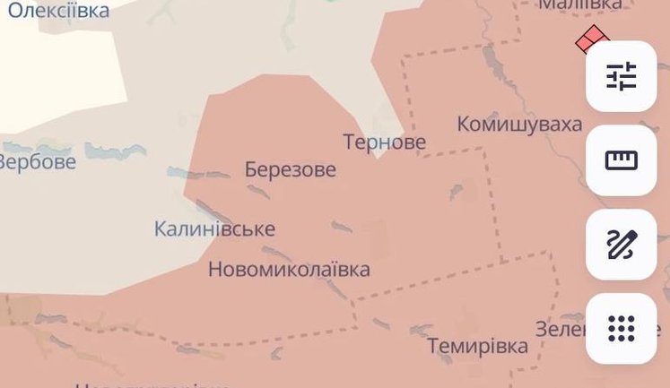
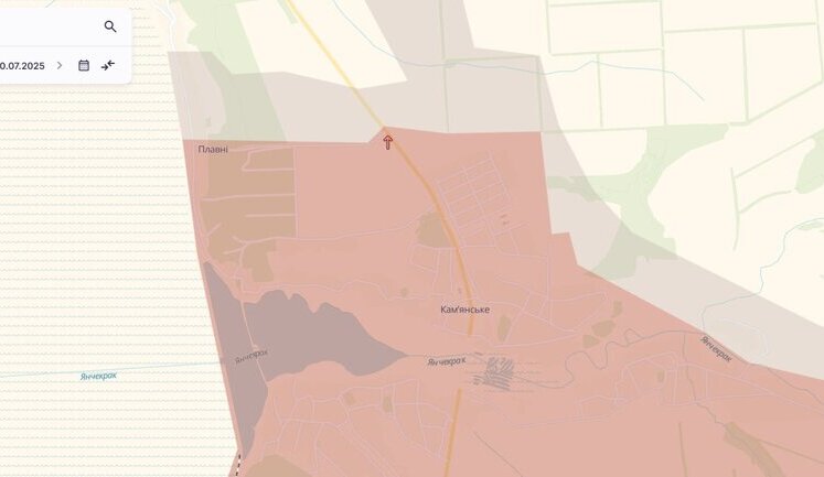
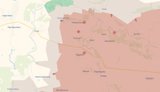
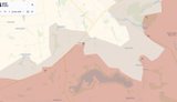
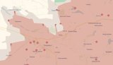
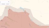
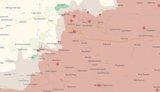
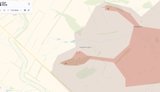
DeepState maps have recently been updated to reflect significant advancements by Russian forces across various regions in Ukraine, including Sumy, Donetsk, and Zaporizhzhia. In the Sumy region, Russian troops have been observed advancing near Novodmytrivka and Stepka. Similarly, in the Donetsk region, notable advances have been reported near Rodynske, Krasnyi Lyman, and other settlements within the Pokrovsk district. Additionally, the Zaporizhzhia region has witnessed moves by Russian troops near Zelene and Huliaipole. The updated maps provide a strategic view of the current situation, highlighting areas of conflict and control within Ukraine. The ongoing movements emphasize the dynamic and shifting nature of territorial engagements, with particular focus on regions like Kharkiv and Bakhmut, where both advances and retreats have been documented extensively.
What regions are highlighted in the updated DeepState maps?
The updated DeepState maps particularly highlight advances by Russian forces in the Sumy, Donetsk, and Zaporizhzhia regions. These areas have shown increased military activity, with significant movements near settlements such as Novodmytrivka, Stepka, Rodynske, and Krasnyi Lyman, among others.
How are the current advances impacting the situation in Ukraine?
The current advances reported in the DeepState maps signify an escalation in military activity in key regions of Ukraine. This has implications for local security, population displacement, and broader geopolitical dynamics, as control over these territories remains contested, leading to continuous changes in frontline positions.
Which military forces are involved in the advancements shown in the maps?
The advancements shown in the updated DeepState maps involve Russian forces actively moving through and taking control of territories in Sumy, Donetsk, and Zaporizhzhia. Ukrainian forces continue to engage in defensive actions aimed at countering these advances and regaining control over strategic areas.
Are specific towns or cities being targeted in the recent advancements?
Yes, specific towns and cities such as Novodmytrivka, Stepka in Sumy, and areas within Donetsk like Rodynske and Krasnyi Lyman have been particularly targeted in the recent advancements. These locations are strategically important for controlling access and supply routes within the affected regions.
What role do maps like DeepState play in understanding the conflict?
Maps like DeepState are crucial for understanding the real-time dynamics of the conflict, providing detailed geographical insights into territorial control and military movements. They help visualize the conflict's scope and scale, enabling better strategic planning and humanitarian response from international observers and involved parties.
How reliable are the reports from DeepState regarding military advances?
Reports from DeepState regarding military advances are generally considered reliable, as they compile data from various on-the-ground sources, satellite imagery, and intelligence reports. However, the complex and rapidly changing nature of military conflicts means that continuous updates are necessary to maintain accuracy.
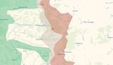
Have the Ukrainian forces made any significant counterattacks according to the maps?
According to the maps, Ukrainian forces have made several significant counterattacks, regaining control near areas such as Ambarne in the Kharkiv region. These efforts are part of ongoing military operations to repel Russian advances and stabilize the threatened regions.
What is the strategic importance of the Sumy, Donetsk, and Zaporizhzhia regions?
The Sumy, Donetsk, and Zaporizhzhia regions hold strategic importance due to their geographic location, serving as key points for both supply lines and territorial control in Eastern Ukraine. Their control influences military logistics, regional security, and the socio-economic stability of the area.
w117_header_alt Updated DeepState maps
 129th SHMB has liberated Odradne in Kharkiv region, – DeepState. MAP The defence forces have carried out a successful operation and liberated Odradne in the Kharkiv region. The settlement and its surroundings have been fully returned to Ukrainian control, and the enemy has suffered casualties. 7 119 10 Previously in trend: Updated DeepState maps
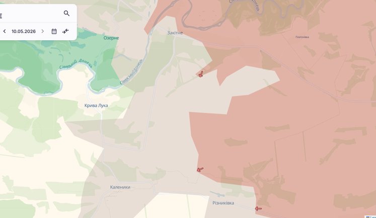
 Russian forces have advanced near Zakitne in Donetsk Oblast, - DeepState. MAP Russian occupying forces are advancing in the Kramatorsk district of Donetsk Oblast. 4 108 5 Previously in trend: Updated DeepState maps
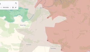
 Enemy has advanced near Pazeno, Kalenyky and in Riznykivka in Donetsk Oblast, - DeepState The enemy has advanced in the Bakhmut and Kramatorsk districts of Donetsk Oblast. 3 254 9 Previously in trend: Updated DeepState maps
 Enemy has advanced near Zakitne in Donetsk Oblast, - DeepState. MAP Russian forces have advanced near Zakitne in the Donetsk region. 1 983 2 Previously in trend: Updated DeepState maps Attack on the Bryansk Chemical Plant
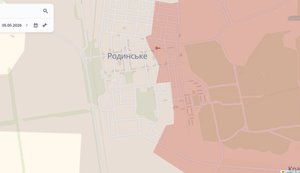
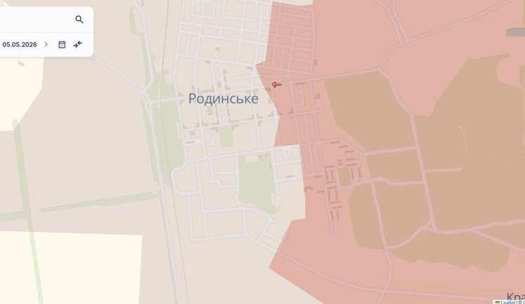
 Enemy advances near Pishchane and in Rodynske – DeepState. MAPS Russian occupation forces have advanced in Kharkiv Oblast and in Pokrovsk district, Donetsk Oblast. 3 421 9 Previously in trend: Updated DeepState maps
 Russian forces have advanced near Andriivka-Klevtsove in Donetsk region, — DeepState. MAP Russian occupation forces have advanced into the Volnovakha district of the Donetsk region. 2 820 2 Previously in trend: Updated DeepState maps
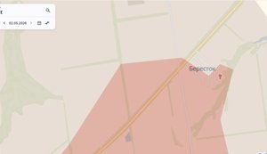
 Enemy has advanced near Berestok and Ivanopillia in Donetsk region, - DeepState. MAP Russian forces are advancing in the Kramatorsk district of the Donetsk region. 2 664 3 Previously in trend: Updated DeepState maps
 Russian troops have advanced near Riznykivka in Donetsk region, - DeepState. MAP Russian forces are advancing in the Bakhmut district of the Donetsk region. 1 809 2 Previously in trend: Updated DeepState maps
 Defense Forces carry out clearing operation near Rodynske and Vilne, enemy advances in Pokrovsk district – DeepState. MAPS Russian occupation forces have advanced in the Pokrovsk district, Donetsk Oblast, while the Defense Forces cleared areas near two settlements. 3 156 0 Previously in trend: Updated DeepState maps Update of DeepState map
 Russians have advanced near Berestok in Donetsk region, - DeepState. MAP Russian occupation forces are advancing in the Kramatorsk district of the Donetsk region. 2 389 0 Previously in trend: Updated DeepState maps
 Enemy has advanced near Pokrovsk and Myrnohrad, - DeepState. MAP Russian occupation forces have advanced in the Pokrovsk direction. 4 392 8 Previously in trend: Updated DeepState maps
 Enemy has advanced near Petropavlivka in Kharkiv region and near Kostiantynivka in Donetsk region. MAP Russian occupation forces are advancing in the Donetsk and Kharkiv regions. 3 374 14 Previously in trend: Updated DeepState maps
 Russian forces have advanced near Synkivka in the Kharkiv region, - DeepState Russian forces are advancing in the Kupiansk district of the Kharkiv region. 4 620 20 Previously in trend: Updated DeepState maps Update of DeepState map
 Russian forces advance in Rodynske, Donetsk Oblast – DeepState. MAP Russian forces have gained ground in the Pokrovsk district, Donetsk Oblast. 2 860 0 Previously in trend: Updated DeepState maps
 Occupiers advance near Hryshyne and Novooleksandrivka – DeepState. MAPS Russian troops have gained ground in the Pokrovsk district, Donetsk region. 2 226 3 Previously in trend: Updated DeepState maps Update of DeepState map
 Enemy is advancing near Myrne in Zaporizhzhia region, - DeepState. MAP Russian occupiers are advancing in the Zaporizhzhia region. 2 474 3 Previously in trend: Updated DeepState maps
 Enemy has advanced in Sumy and Donetsk regions, - DeepState (updated). MAPS Russian occupiers are reportedly advancing in the Sumy region, near two settlements, and also near Donetsk region. 9 619 32 Previously in trend: Updated DeepState maps Fighting in Sumy region
 Occupiers advance in Rodynske and Krasnyi Lyman – DeepState. MAPS Russian forces are advancing in the Pokrovsk district of Donetsk Oblast. 3 884 6 Previously in trend: Updated DeepState maps Update of DeepState map
 Russian forces have advanced near Novodmytrivka and Stepka in Sumy region, - DeepState Russian occupation forces are advancing in the Sumy region. 4 481 34 Previously in trend: Updated DeepState maps
 Russian troops have advanced near Zelene and in Huliaipole in Zaporizhzhia Oblast, – DeepState. MAP Russian troops have been observed advancing near Zelene and in Huliaipole in the Zaporizhzhia region. 3 071 5 Previously in trend: Updated DeepState maps
 Enemy has advanced near Riznykivka in Donetsk region, - DeepState. MAP Russian forces are advancing in the Bakhmut district of the Donetsk region. 2 073 0 Previously in trend: Updated DeepState maps Update of DeepState map
 Enemy has advanced near Pishchane and Rodynske – DeepState. MAPS Russian occupation forces have advanced in the Kharkiv and Donetsk regions. 3 513 11 Previously in trend: Updated DeepState maps
 Russian forces have advanced in the Kharkiv and Donetsk regions, - DeepState Russian troops have advanced near Petropavlivka in the Kharkiv region and Stupochky in the Donetsk region. 3 879 2 Previously in trend: Updated DeepState maps
 Occupiers advance in Hryshyne and near Kotlyne – DeepState. MAPS Russian occupation forces have gained ground in the Pokrovsk district, Donetsk Oblast. 4 248 16 Previously in trend: Updated DeepState maps Update of DeepState map Russian advance
 AFU have regained control near Ambarne in Kharkiv region, - DeepState Ukrainian forces have regained control of the area near Ambarne in the Kharkiv region. 4 232 3 Previously in trend: Updated DeepState maps
 Russians have advanced near Pryvillia in Donetsk region, - DeepState. MAP Russian occupation forces are advancing in the Bakhmut district of the Donetsk region. 2 859 14 Previously in trend: Updated DeepState maps Situation in the Donetsk region
 Defence Forces carried out mop-up operation near Stepnohirsk, Novoselivka and Sichneve, - DeepState. MAP The defence forces are making territorial gains in the Zaporizhzhia and Dnipropetrovsk regions. 5 232 1 Previously in trend: Updated DeepState maps
 Enemy has advanced in Sumy Oblast, AFU have regained their positions near Rodynske, - DeepState. MAP Russian troops are advancing near Riasne in the Sumy region. 3 879 5 Previously in trend: Updated DeepState maps
 Enemy has advanced near Pishchane, - DeepState. MAP Russian troops are advancing near Pishchane in the Kharkiv region. 2 836 3 Previously in trend: Updated DeepState maps Hostilities in Kharkiv region
 Enemy has advanced near Pishchane and Novopavlivka, - DeepState. MAP Russian forces are advancing in the Kharkiv and Donetsk regions. 3 939 13 Previously in trend: Updated DeepState maps
 Defence forces carried out sweep near Orestopil and Oleksiivka, enemy advanced near Pazeno, Rusyn Yar and Varvarivka, - DeepState. MAP Defence forces are making gains in the Dnipropetrovsk region, whilst Russian occupiers have advanced in the Donetsk and Zaporizhzhia regions. 2 601 0 Previously in trend: Updated DeepState maps
 Enemy has advanced near Vasiukivka and Fedorivka Druha, - DeepState. MAP Russian forces are currently advancing in the Bakhmut district of the Donetsk region. 3 811 7 Previously in trend: Updated DeepState maps
 Enemy has advanced near Ambarne in Kharkiv region, - DeepState. MAP Russian forces are advancing in the Kupiansk district of the Kharkiv region. 3 904 1 Previously in trend: Updated DeepState maps
 Russia has advanced near Zaliznychne in Zaporizhzhia Oblast, - DeepState. MAP Russian troops have advanced near the village of Zaliznychne, close to Huliaipole in the Zaporizhzhia region. 3 600 2 Previously in trend: Updated DeepState maps
 Enemy has occupied Platonivka and advanced near two settlements in Donetsk region, - DeepState. MAP Russian troops have occupied Platonivka in the Bakhmut district and are advancing in two districts of the Donetsk region. 4 877 33 Previously in trend: Updated DeepState maps Update of DeepState map
 Occupiers have advanced in Riznykivka and near two settlements in Donetsk Oblast, - DeepState. MAP Russian occupiers are advancing in several districts of the Donetsk region. 2 947 6 Previously in trend: Updated DeepState maps
 Ruscists advance near Oleksandrohrad in Donetsk region and Huliaipole in Zaporizhzhia region – DeepState Russian occupiers have gained ground in the Donetsk and Zaporizhzhia regions. 4 001 7 Previously in trend: Updated DeepState maps
 Enemy advanced near Orikhovo-Vasylivka, Minkivka and in Vasiukivka – DeepState. MAP Russian forces have gained ground in the Bakhmut district of the Donetsk region. 3 543 7 Previously in trend: Updated DeepState maps
 Russians have advanced near Myrne in Zaporizhzhia region, - DeepState. MAP Russian troops have been observed advancing near Myrne in the Zaporizhzhia region. 4 693 12 Previously in trend: Updated DeepState maps
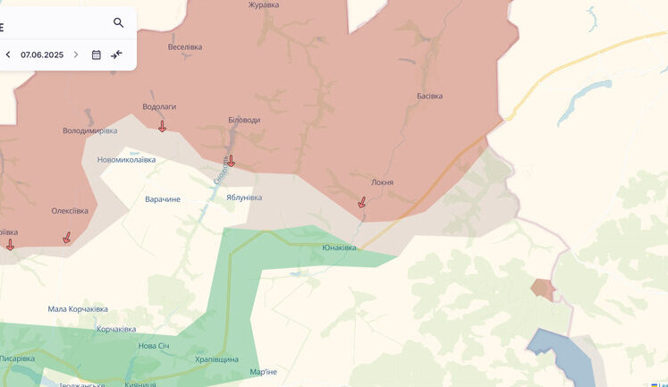
 Russian troops have advanced near Yablunivka in Sumy region – DeepState. MAP Russian occupiers have gained ground in the Sumy district of the Sumy region. 4 537 26 Previously in trend: Updated DeepState maps Update of DeepState map
 Enemy gains ground in Berestok and near Fedorivka Druha in Donetsk region – DeepState Russian forces have gained ground in the Kramatorsk and Bakhmut districts of the Donetsk region. 3 231 16 Previously in trend: Updated DeepState maps Update of DeepState map
 Enemy has advanced in Sumy and Donetsk regions, - DeepState. MAP Russian troops are advancing in the Sumy and Donetsk regions. 5 301 8 Previously in trend: Updated DeepState maps Update of DeepState map
 Enemy advances near Piddubne in Donetsk region – DeepState. MAP Russian forces have made gains in the Donetsk region. 2 182 6 Previously in trend: Updated DeepState maps
 Enemy has advanced near Huliaipole, - DeepState. MAP Currently, Russian troops are advancing in the Huliaipole direction. 4 416 17 Previously in trend: Updated DeepState maps
 Enemy advances in two settlements in Donetsk and Zaporizhzhia regions – DeepState. MAPS Russian occupation forces have gained ground in the Donetsk and Zaporizhzhia regions. 3 801 6 Previously in trend: Updated DeepState maps Update of DeepState map
 Enemy has advanced near Dorozhnianka in Zaporizhzhia region, - DeepState. MAP Russian occupation forces are advancing in the Zaporizhzhia region. 3 911 4 Previously in trend: Updated DeepState maps
 Enemy has advanced near Markove, Rivne, and Hryshyne, - DeepState. MAP Russian occupation forces are advancing in the Kramatorsk and Pokrovsk districts of Donetsk Oblast. 3 307 25 Previously in trend: Updated DeepState maps
 Enemy has advanced near Platonivka, Novooleksandrivka, in Riznykivka and Hryshyne, - DeepState. MAP Russian occupation forces are advancing in the Bakhmut and Pokrovsk districts of the Donetsk region 3 921 18 Previously in trend: Updated DeepState maps
Page 1 of 6
more news